
Stormy Weather Set to Light Up I-95 CorridorIntense Heat, Stormy Weather Across the U.S. Today
Stormy Weather Set to Light Up I-95 Corridor
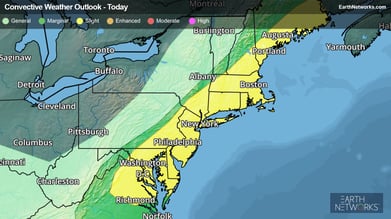
By Earth Networks Meteorologist, Mark Ellinwood
A cold front will push through the eastern U.S. today, triggering strong to severe storms from Maine to Virginia.
 Days of high heat and humidity will come to an end for many in the Northeast and Mid-Atlantic thanks to the cold front pushing through these regions today, but it will come at the cost of thunderstorms.
Gusty winds will be the main threat with the storm activity this afternoon and evening, but a couple of tornadoes could also spawn along the front in the Northeast.
Areas along and east of the I-95 corridor from Maine to Richmond, Va. will be the most susceptible to severe weather today as clusters of storms form along and ahead of the cold front. This includes Boston, New York City, Philadelphia, Baltimore, and Washington, D.C.
Be sure to understand the difference between severe thunderstorm or tornado watches and warnings. When a watch is issued, then conditions are favorable for dangerous weather. When a warning is issued, it means that dangerous weather has already been observed and is imminent in your location, and you should take immediate action to protect life and property.
Intense Heat, Stormy Weather Across the U.S. Today
By Earth Networks' Richard Romkee
Most of the U.S. will have to deal with thunderstorms, with the most dangerous of these being found along the Interstate 95 corridor.
-Jul-25-2022-11-11-46-11-AM.png?width=391&name=National_ForecastMap_Day1_EarthNetworks%20(5)-Jul-25-2022-11-11-46-11-AM.png)
This morning will begin with showers and thunderstorms moving across the central Plains, with some isolated showers also possible in Arizona. Thunderstorms will also persist during the early parts of the morning ahead of a slow-moving cold front across the Northeast, with a few storms also possible in the Mid-Atlantic region.
By the early afternoon hours, new thunderstorms will develop along the cold front from the Midwest to the Northeast. Some of these storms could produce strong wind gusts, large hail, and perhaps an isolated tornado. This risk is highest along and east of the Interstate 95 corridor north of Richmond, Virginia. Heavy rainfall may also cause flooding with these storms, especially in the Appalachian Mountains and across the Tennessee River Valley. If you encounter a flooded roadway, remember: “Turn Around, Don’t Drown!”
Thunderstorms will also erupt across the southern Rockies and Desert Southwest by the late morning hours and slowly move northeast. Gusty winds, small hail, and torrential rainfall will be the main threats with these storms. The risk of flash flooding with these storms is relatively high, mainly in Arizona, southern Utah, and southwestern Colorado.
The northern Rockies and central Plains could also see showers and storms along the cold front. These storms may produce strong wind gusts as they move east, primarily in southwestern South Dakota and the Nebraska Panhandle. Flash flooding is also a concern with these storms, mainly in Missouri and southeastern Nebraska where storms could produce as much as 2 to 4 inches of rainfall.
Spotty thunderstorms will also be common across the Southeast and South, producing heavy rainfall and gusty winds as well as frequent lightning.
Much of the nation will experience hot weather again today, though the cold front will bring some relief to the Midwest and northern Plains. The Pacific Northwest will also bake under a building heat wave, with daily record highs possible in Yakima, Wash., and Medford, Ore.
Highs will be in the 70s and 80s for the northern Plains, Upper Mississippi Valley, and Midwest, with 80s and 90s for the Rocky Mountains, Northeast, Mid-Atlantic, and Southeast. There will be 90s and 100s in the Pacific Northwest, West, Intermountain West, Desert Southwest, southern Plains, and Lower Mississippi Valley.